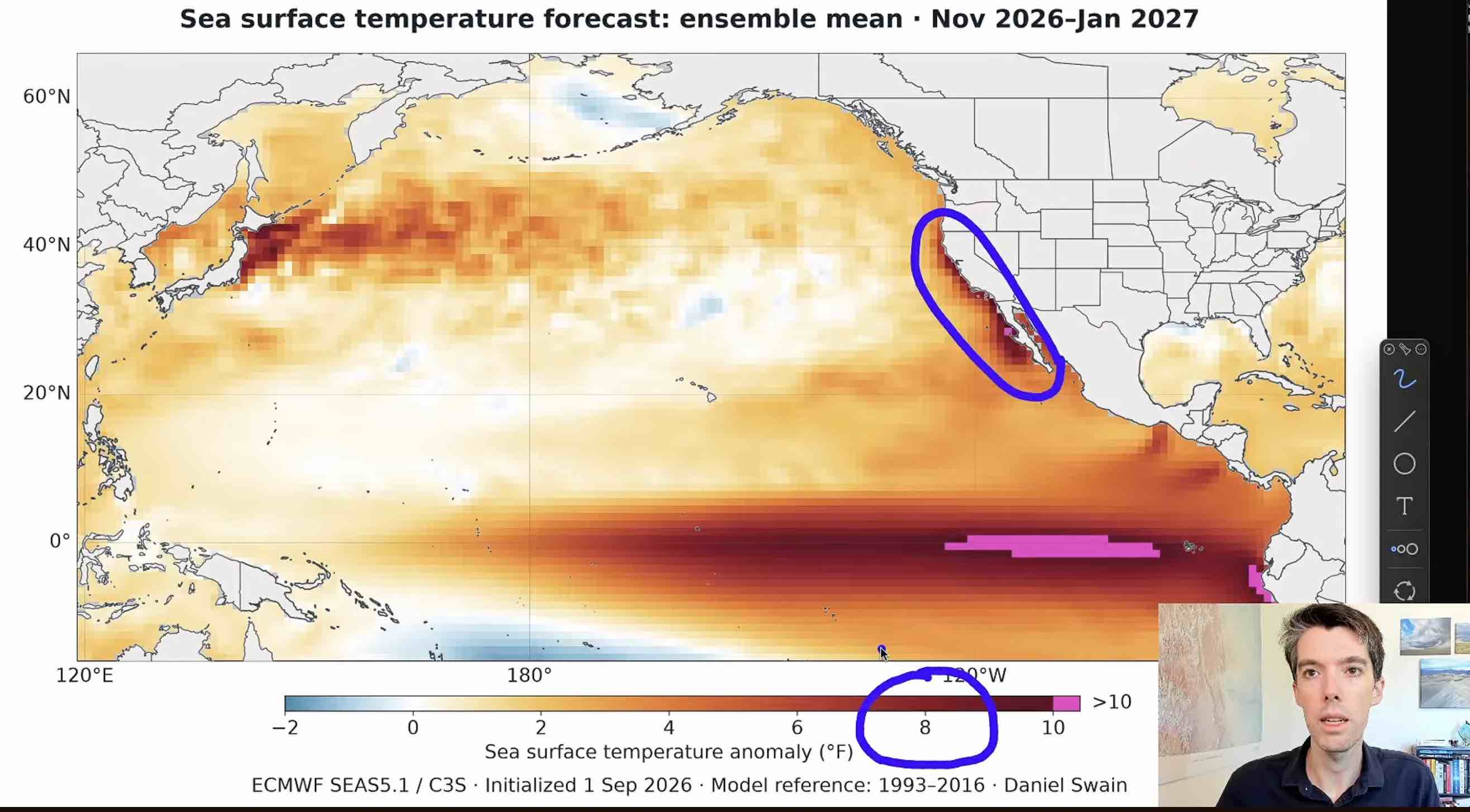
 A strong Super El Niño has developed in the tropical Pacific that is expected to intensify and become a historic event by late 2026. We can expect this winter to bring heavy rainfall, a marine heatwave, and the highest sea levels California has ever seen.On Sept. 30, Blue Lake Rancheria will hold a Flood Fight Training Workshop. You can register online for the workshop or call (707) 668-5101 for more info. You can also sign up for Humboldt ALERT to receive official flood warnings and evacuation information. What is a Super El Niño?During normal oceanic and atmospheric conditions, trade winds blow from east to west across the tropical Pacific, pushing warm waters towards Asia and Australia. This pattern results in upwelling when colder water rises from deeper parts of the ocean along the west coast of South America. An El Niño event begins when these trade winds weaken, allowing warm surface water to spread eastward, decreasing cold water upwelling. As the Central and Eastern Pacific Oceans warm, clouds and rainfall shift eastward, which can even further weaken the trade winds, allowing even more warm water to move eastward. This creates a feedback loop that allows additional warming to occur.An El Niño event is declared when monthly sea surface temperatures in the central and eastern tropical Pacific Ocean warm +0.5° Celsius above normal for at least five consecutive, overlapping three-month periods, and trade winds weaken. When water temperatures become exceptionally high, the event is referred to as a Super El Niño. In late August, ocean temperatures were the highest ever documented since record-keeping began in 1979, and in the face of an El Niño event will likely continue to rise over the next few months.How Does an El Niño Event Affect Sea Level Rise?El Niño events can temporarily raise sea level along our coast, increasing the risk of coastal flooding in low-lying areas. Sea levels are rising globally as the planet warms. As ocean water temperatures increase, water expands and takes up more space - a process known as thermal expansion. In addition, melting ice on land adds more water to the ocean. Humboldt Bay, however, faces an additional local challenge. While the ocean is rising, land around the bay is also slowly sinking, a process known as subsidence. Together, rising ocean levels and subsiding land cause relative sea level to rise faster in Humboldt Bay, increasing the risk of flooding for low-lying communities.During El Niño events, unusually warm water spreads eastward across the Pacific, further increasing water temperatures and thermal expansion. Long Kelvin waves carry this warm water toward the coasts of North and South America, raising the sea-surface height as much as the height of the wave and further contributing to changes in sea level. These temporary increases can become even greater when they align with high astronomical tides, large waves, onshore winds, heavy rainfall and storm surge, all weather patterns associated with an El Niño event. When El Niño’s effects are layered on top of global sea level rise and local land subsidence, coastal water levels can become especially high, making flooding in Humboldt Bay more likely and potentially more severe.Reading Tide ChartsIn Humboldt Bay, the North Spit tide gauge is managed by the National Oceanic and Atmospheric Administration (NOAA) and continuously measures water levels near the U.S. Coast Guard Station. This tide chart shows the predicted times and heights of high and low tides in Humboldt Bay (in blue) and compares those predictions with actual water heights measured by the gauge (in red).
 Tide charts only show predictions based on sun and moon cycles, and do not predict the influences of storm surge, winds, and other weather events. Coastal flooding is more likely when a very high tide occurs during an El Niño. Because of this, it is important to pay particular attention to the highest predicted tide of the day and whether it occurs during storm conditions. Tide predictions should therefore be treated as a starting point rather than a complete coastal-flood forecast.During an El Niño event, check NOAA tide predictions together with coastal flood advisories from the National Weather Service and local emergency alerts. The most dangerous conditions can occur when an unusually high tide and an El Niño-driven storm arrive at the same time. This year’s event is predicted to be a fairly dry October to November, with more extreme weather events beginning in December.How to Prepare for Coastal FloodingIf you live or work in a low-lying area around Humboldt Bay, it is important to prepare before high tides and storms arrive. Coastal flooding can develop quickly, especially during a Super El Niño. Here is what you can do ahead of time to ensure you are prepared for a flooding event:
- Sign up for Humboldt ALERT to receive official flood warnings and evacuation information.
- Prepare an emergency kit and an emergency plan for your household. Humboldt County recommends having enough supplies to sustain your household for two weeks.
- Monitor tides and weather conditions. Check NOAA's North Spit tide gauge and follow the National Weather Service's Eureka office for coastal flood advisories and storm warnings. Remember that actual water levels may rise above predicted tides during a storm.
- Locate your home on FEMA Flood Maps to know what types of flood risk you can expect. If flood hazards (blue area) are of risk in your area, monitor tides and weather conditions.
- Consider buying flood insurance. Because most homeowners and renters policies do not cover flooding, the National Flood Insurance Program offers flood coverage. Homeowners, renters, and businesses can purchase a policy regardless of whether they are in a high-risk flood zone, but coverage generally takes 30 days to take effect. Make sure to see if this would be a good fit to you prior to flooding events.
- Locate your home or property on our interactive Sea Level Rise Map to see if your neighborhood is at risk in the future.
- Plan where you will evacuate. Identify a safe location on higher ground that you can reach quickly without traveling through flood-prone areas. Plan more than one evacuation route in case roads are closed or flooded.
- Protect your home and belongings. Clear gutters and storm drains, raise vehicles and valuable belongings to higher ground, and store important documents in waterproof containers. If flooding is expected, use sandbags where appropriate and only when it is safe to do so.
Important terms to know:
A Coastal Flood WATCH means that sea water spillage over dune lines and sea walls will occur if weather develops as expected. People in the watch area should be ready to move to safe ground if flooding occurs or if warnings are issued.
A Coastal Flood WARNING means that sea water spillage over dune lines and sea walls is occurring, is imminent or is expected within the next 12 hours. People in the warned area should take immediate action to protect lives and property.


